


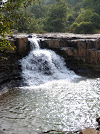
ଡୋକରିଚଞ୍ଚରା
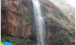
ଡୋକରି ଚଞ୍ଚରା ଜଳ ପ୍ରପାତ
କଳାହାଣ୍ଡି ଜିଲ୍ଲା ଓଡିଶା ର ଏକ ପୁରାତନ ତଥା ଐତିହ ସମ୍ପନ୍ନ ସ୍ଥାନ ଅଟେ । କଳାହାଣ୍ଡି ର ଅନେକ ପର୍ଯ୍ୟଟନ ସ୍ଥଳୀ ମାନଙ୍କ ଠାରୁ , ଏକ ଅନନ୍ୟ ଓ ସମ୍ପୂର୍ଣ ଭିନ୍ନ ପର୍ଯ୍ୟଟନ ସ୍ଥଳୀ ହେଉଛି ଡୋକରୀଚଞ୍ଚରା । କଳାହାଣ୍ଡି ଜିଲ୍ଲାର କୋକସରା ବ୍ଲକ ଓ ନବରଙ୍ଗପୁର ଜିଲ୍ଲାର ସୀମାନ୍ତ ବର୍ତ୍ତୀ ଅଞ୍ଚଳ ରେ ଏହା ଅବସ୍ଥିତ । ଡୋକରୀଚଞ୍ଚରା ରେ ଥିବା ଦୁଇଟି ପ୍ରମୁଖ ଜଳପ୍ରପାତ ପାଇଁ ଏହା ସାରା ଜିଲ୍ଲାରେ ପ୍ରସିଦ୍ଧ । ଗୋଟିଏ ହେଲା ଡୋକରୀଦର ଓ ଅନ୍ୟଟି ଭାନ୍ୟର ଘୁମର (ଦା ଭୈରବଦର) । ଏତଦ୍ ବ୍ୟତୀତ ଏହା ପାଖରେ ଥିବା ପ୍ରାକ ଐତିହାସିକ ଯୁଗର ଗୁଡାହାଣ୍ଡି ଗୁମ୍ଫା ଏହି ପର୍ଯ୍ୟଟନ ସ୍ଥଳୀ କୁ ଏକ ସ୍ଵତନ୍ତ୍ର ପରିଚୟ ପ୍ରଦାନ କରିଛି । ଗୁଡ ରେ ପରିପୂର୍ଣ ହାଣ୍ଡି ପରି ଦେଖାଯାଉଥିବାରୁ ଏହି ଗୁମ୍ଫାର ନାମ କରଣ ଏହି ପରି ହୋଇଛି ବୋଲି କିମ୍ବଦନ୍ତୀ କୁହେ ।
ଏହି ଗୁଡହାଣ୍ଡି ଗୁମ୍ଫାର ବିଶେଷତ୍ଵ ହେଉଛି ଏଥିରେ ଅବିଷ୍କୃତ ହୋଇଥିବା ପ୍ରାକ ଐତିହାସିକ ଯୁଗର ବିଭିନ୍ନ ଚିତ୍ର, ଶିଳାଲେଖ ତଥା ଗୁମ୍ଫାର କାନ୍ଥ ଗୁଡିକରେ ଖୋଦିତ ହୋଇଥିବା ବିଭିନ୍ନ ଚିତ୍ର । ଡ଼ୋକରୀଚଞ୍ଚରା ପରିବେଶ ମଧ୍ୟରେ ଥିବା ଏକ ପୁରାତନ ତଥା ପ୍ରାଚୀନ ଶ୍ରୀରାମ ମହାପ୍ରଭୁଙ୍କ ମନ୍ଦିର ଏହି ସ୍ଥଳୀ କୁ ଅଧ୍ୟାତ୍ମିକତାର ଏକ ବିଶେଷ ମାନ୍ୟତା ପ୍ରଦାନ କରିଛି । ପ୍ରତି ବର୍ଷ ଏହି ରାମ ମନ୍ଦିର ପରିସର ରେ ଶ୍ରୀ ରାମ ନବମୀ ମହୋତ୍ସବ ନଅ ଦିନ ଧରି ଆନନ୍ଦ ଉଲ୍ଲାସର ସହିତ ପାଳନ କରାଯାଇଥାଏ ।
ଏଠାରେ ଥିବା ଡ଼ୋକରୀଦର ଜଳପ୍ରପାତ ୨୦୦ ଫୁଟ ଉଚ୍ଚତା ବିଶିଷ୍ଟ ଏବଂ ଏହି ଜଳ ଧାରା ର କଡେ କଡେ ଗଲେ ୨ କିମି ଯିବା ପରେ ପ୍ରସିଦ୍ଧ ଭାନ୍ୟରଘୁମର ( ବା ଭୈରବ ଧର ) ଜଳ ପ୍ରପାତ ଅଛି ଯାହା କି ୧୫୦ ଫୁଟ ଉଚ୍ଚ ଉପରୁ ପତିତ ହୋଇଥାଏ । କେଉଁ ଆବାହମାନ କାଳରୁ ଏହି ଅଂଚଳର ଆରାଧ୍ୟ ଦେବୀ ମା ଡ଼ୋକରୀ ଦେବୀ ଙ୍କୁ ଏହି ସ୍ଥଳୀରେ ପୂଜାର୍ଚ୍ଚନା କରାଯାଇଥାଏ । ଏହି ପର୍ଯ୍ୟଟନ ସ୍ଥଳୀ ର ବିଶେଷତ୍ଵ ହେଲା ପାଖରେ ଦଣ୍ଡାୟମାନ ହୋଇଥିବା ଯୋଗୀ ପାହାଡ଼ ଓ ରାଣୀ ପାହାଡ଼ ଯାହାକି ପ୍ରକୃତିକ ସବୁଦିମାରେ ଭରପୁର ରହିଛି ।
ପାଖ ରେଳ ଷ୍ଟେସନ :ଜୁନାଗଡ , ଭବାନୀପାଟଣା
ପାଖ ବିମାନ ବନ୍ଦର : ଭୁବନେଶ୍ବର, ରାୟପୁର ,ବିଶାଖାପାଟଣା
କିପରି ପହଞ୍ଚିବେ : ଭୁବନେଶ୍ଵର, ରୁ ୫୫୦+କିମି ରାସ୍ତା, ବସ ଓ ରେଳ ପ୍ରତି ଦିନ ଚାଲିଥାଏ । ଭୁବନେଶ୍ଵର ରୁ ଭବାନୀପାଟଣା ( କଳାହାଣ୍ଡି ଜିଲ୍ଲା ସଦର ମହକୁମା ) ଏବଂ ଭବାନୀପାଟଣା ରୁ ଭଡା ଗାଡି ଯୋଗେ କୋକସାରା ବ୍ଲକ ଦେଇ ଡୋକରିଚଞ୍ଚରା ଜଳ ପ୍ରପାତ କୁ ପହଞ୍ଚି ପାରିବେ ।
ଫୁର୍ଲିଝରଣ
ଫୁର୍ଲିଝରଣ ଜଳ ପ୍ରପାତ
ଫୁର୍ଲିଝରଣ ଭବାନୀପାଟଣା ଠାରୁ ପନ୍ଦର କିଲୋମିଟର ଦୂରରେ ଅବସ୍ଥିତ । ଏହା କର୍ଲାପାଟ ଅଭୟାରଣ୍ୟ ର ଏକ ଅଂଶ ବିଶେଷ । ଏହାର ଉଚ୍ଚତା ପ୍ରାୟ ୩୦ ଫୁଟ । ଏହି ଜଳ ପ୍ରପାତ ର ନିଜସ୍ୱ ସୁନ୍ଦରତା ଅଛି । ସୂର୍ଯ୍ୟ କିରଣ ପଡିଲେ ସୁନ୍ଦର ଇନ୍ଦ୍ରଧନୁ ସବୁ ଦେଖା ଯାଇଥାଏ । ଏହି ଜଳ ପ୍ରପାତ କୁ ଘେରି ରହିଛି ବଣ ପାହାଡ ଘେରା ଅପୂର୍ବ ମୋନହର ଦୃଶ୍ୟ । ବର୍ଷ ତମାମ ଏହି ପର୍ଯ୍ୟଟନ ସ୍ଥଳୀରେ ଓଡିଶା ରାଜ୍ୟ ର ବିଭିନ୍ନ ଜିଲ୍ଲା ମାନଙ୍କରୁ ତଥା ରାଜ୍ୟ ବାହାରୁ ଅନେକ ଲୋକ ଙ୍କ ଏଠାରେ ସମାଗମ ହୋଇଥାଏ ।
ପାଖ ରେଳ ଷ୍ଟେସନ : ଭବାନୀପାଟଣା
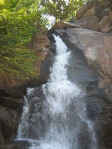
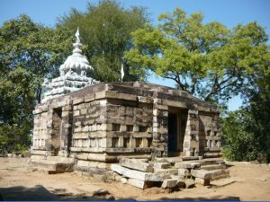
ଗୁଡହାଣ୍ଡି
ଡୋକରିଚଞ୍ଚରା ପାଖରେ ଥିବା ଗୁଡହାଣ୍ଡି ଜଳ ପ୍ରପାତ
ଗୁଡହାଣ୍ଡି ପର୍ବତ, ଖାଲିଗଡ ନାମକ ଏକ ଛୋଟ ଗ୍ରାମ ପାଖରେ ଅବସ୍ଥିତ ଯାହା ର ସୀମା ନବରଙ୍ଗପୁର ଜିଲ୍ଲା କୁ ଲାଗିଛି । ଏହା ଆମପାଣି ଠାରୁ ୧୭.୬ କିମି ଉତ୍ତର-ପୂର୍ବ ରେ ଅବସ୍ଥିତ ଏବଂ ଆମପାଣି , ଭବାନୀପାଟଣା ଠାରୁ ୭୭ କିମି ଦୂରରେ ଅବସ୍ଥିତ । ଗୁଡହାଣ୍ଡି ପର୍ବତ ରେ ପୁରାତନ ଯୁଗ ର କିଛି ଗୁମ୍ଫା ଅଛି ସେଥିରେ ଆଦିମାନବ ସଭ୍ୟତା ର କିଛି ପ୍ରସ୍ତର ଚିତ୍ର ଅଙ୍କା ହୋଇଥିବା ଦେଖିବାକୁ ମିଳି ଥାଏ । ତିନୋଟି ଛୋଟ ଗୋଲାକାର ପାହାଡ କୁ ମିଳିତ ଭାବେ ଗୁଡହାଣ୍ଡି କୁହାଯାଇଥାଏ ।
ଉତ୍ତର ଓ ଦକ୍ଷିଣ ପର୍ବତ ମାଳା ପୁର୍ବରେ ମିଶିଛି ଓ ପଶ୍ଚିମ ଦିଗରେ ଖୋଲା ସ୍ଥାନ ରହିଛି । ପୂର୍ବ କୁ ତିଖ ପଥର ସବୁ ଅଛି। ଏହାର ପାଦଦେଶରେ ପର୍ବତ ମାଳା କୁ ସାମନା କରି ଗୁମ୍ଫା ଗୁଡିକ ଧାଡି କରି ରହିଅଛି। ଉତ୍ତର ପଟର ଗୋଟିଏ ଗୁମ୍ଫା କୁ ଛାଡିଦେଲେ ଅନ୍ୟ ସମସ୍ତ ଗୁମ୍ଫା ଗୁଡିକ ଛୋଟ ଛୋଟ ଅଟେ । ଏହି ଜାଗା ଲାଲ ସିଲଟ ପଥର ଦ୍ଵାରା ଆଚ୍ଛାରିତ । ଦକ୍ଷିଣ ଧାଡିରେ ଥିବା କିଛି ଗୁମ୍ଫା ର ପ୍ରବେଶ ଦ୍ଵାର ରେ ଲାଲ ଓ କଳା ରଙ୍ଗ ର ପ୍ରସ୍ତର ଚିତ୍ର ସବୁ ଦେଖିବାକୁ ମିଳିଥାଏ। ଏହି ଐତିହାସିକ ସ୍ଥଳୀ ର ପର୍ଯ୍ୟନ୍ତ ଉପଯୁକ୍ତ ଅଧୟନ କରାଯାଇନାହିଁ କିନ୍ତୁ ସାଧାରଣତଃ ଅନୁମାନ କରାଯାଏ ଯେ ଏହି ଚିତ୍ରାଙ୍କନ ସବୁ ପ୍ରାୟ ସିନ୍ଧୁ ଘାଟି ସଭ୍ୟତା ସମୟ ର ହୋଇଥାଇ ପାରେ ।
ଆମାଠଗଡ
ଆମାଠଗଡ ଦୁର୍ଗ ତେଳନଦୀ ଉପତ୍ୟକା ର ପୂର୍ବ ତଟ କୁଳ ରେ ଅବସ୍ଥିତ । ଏହି ରାସ୍ତା ଦେଇ ନଦୀ ପାର ହୋଇ ବଲାଙ୍ଗିର ଜିଲ୍ଲା ଆଡକୁ ଯିବା ପାଇଁ ଯୋଗ ଯୋଗ ରହିଛି । ଏହି ଆମାଠଗଡ ବର୍ତ୍ତମାନ ସମ୍ପୂର୍ଣ୍ଣ ଭାବରେ ବିଲୁପ୍ତ ପ୍ରାୟ । ଏହି ସ୍ଥଳୀର ଅଦ୍ୟାବଥି କୌଣସି ଅଧୟନ କରାଯାଇ ପରି ନାହିଁ ତେଣୁ ଏହା ସମ୍ପର୍କ ରେ କୌଣସି ତଥ୍ୟ ସଠିକ ଭାବରେ କୁହାଯାଇ ନାହିଁ ।
ଅସୁରଗଡ
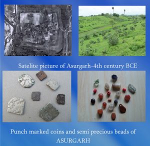
ଅସୁରଗଡ ର ଧ୍ଵଂସାଅବଶେଷ , କୃତ୍ରିମ ଉପଗ୍ରହ ର ଫୋଟୋ ଓ କିଛି ପୁରୁଣା ଗହଣା
କଳାହାଣ୍ଡି ଜିଲ୍ଲା ର ନର୍ଲା ପୋଲିସ ଷ୍ଟେସନ ଅନ୍ତର୍ଗତ ଅସୁରଗଡ ଏକ ଛୋଟ ଗ୍ରାମ । ଏହା ନର୍ଲା ରୁ ୫ କିମି ଏବଂ ରୁପ୍ରା ରୋଡ ରେଳ ଷ୍ଟେସନ ରୁ ୨ କିମି ଦୂରରେ ଅବସ୍ଥିତ । ଗ୍ରାମ ଟି ଅନେକ କିମ୍ବଦନ୍ତୀ ନେଇ ପ୍ରସିଦ୍ଧ । କୁହାଯାଏ ଏହି ଅଞ୍ଚଳ ଟି ଅସୁର ରାଜା ଗୋସିଂହ ଦୈତ୍ୟ ଦ୍ଵାରା ଶାସିତ ଥିଲା । ବର୍ତ୍ତମାନ ଅସୁରଗଡ ଟି ଏକ ଭଗ୍ନ ଦୁର୍ଗ ର ଅଂଶ ବିଶେଷ ହୋଇ ରହିଛି । ଦୁର୍ଗ ର ଭଗ୍ନ ସ୍ତୂପ ଗୁଡିକ ସାନ୍ଦୁଲ ନଦୀ ର କୁଳ ରେ ତଥା ଏକ ଅଣ୍ଡାକୃତି ର ପ୍ରାୟ ୨୦୦ ଏକର ବିଶିଷ୍ଠ ପୁଷ୍କରଣୀ ଦ୍ଵାରା ଘେରି ରହିଛି । କୁହାଯାଏ ଏହାର ଚାରୋଟି ପ୍ରବେଶ ଦ୍ଵାର ରହିଛି ଏବଂ ପ୍ରତ୍ୟକ ପଥ ରେ ଜଣେ ଜଣେ ଦେବୀ ବା ଦେବ ପୂଜା ପାଇ ଆସିଥାନ୍ତି । ପୂର୍ବ ରେ ଗଙ୍ଗା ଦେବୀ , ପଶ୍ଚିମ ରେ କଳା ପାହାଡ , ଦକ୍ଷିଣ ରେ ବୈଷ୍ଣବୀ ଏବଂ ଉତ୍ତର ରେ ବୁଢା ରାଜା ପୂଜା ପାନ୍ତି । ଦୁର୍ଗ ମଧ୍ୟ ରେ ଏକ ଛୋଟ ଗାଁ ରହିଛି ଯେଉଁଠି ମାଁ ଡୋକରି ଦୁର୍ଗର ଅଧିଷ୍ଟ୍ରାତ୍ରୀ ଭାବରେ ପୂଜିତ ହୁଅନ୍ତି । ଏହା କିଛି ମାତ୍ରା ରେ ଅଧୟନ କରା ଯାଇଛି କିନ୍ତୁ ଆହୁରି ଗବେଷଣା ର ଅବଶ୍ୟକତା ରହିଛି ।
ଅମପାଣି
ଅମପାଣି ଅଭୟାରଣ୍ୟ
ଅମପାଣି
ଅମପାଣି , ଭବାନୀପାଟଣା ଠାରୁ ୭୭ କିମି ଦୂରରେ ଅବସ୍ଥିତ । ଅମପାଣି ପର୍ବତ ଶୃଙ୍ଖଳା ପ୍ରକୃତି ର ଏକ ମନୋରମ ଦୃଶ୍ୟ ଦେଖାଇ ଥାଏ । ହଳଦୀଗୁଣ୍ଡି ଘାଟିରେ ସକାଳେ ଓ ସନ୍ଧ୍ଯା ରେ ସୂର୍ଯ୍ୟ କିରଣ ପ୍ରତିଫଳିତ ହୋଇ ବସ୍ତୁ ସବୁ ଅଦ୍ଭୁତ ହଳଦିଆ ରଙ୍ଗ ଦେଖା ଯାଇଥାଏ । ଅଂଚଳ ଅଧୀନରେ ଥିବା ବେହେରା ଜଙ୍ଗଲରେ ହରିଣ ସମ୍ବର ତଥା ବାଘ ଅନେକ ସମୟରେ ଦେଖିବାକୁ ମିଳନ୍ତି । ଏହି ଅଂଚଳର ଲୋକେ ଭୈରବ ବା ବୁଢା ରାଜାଙ୍କୁ ନିଜର ଅଧିଷ୍ଠ ଦେବତା ଭାବରେ ପୂଜା କରିଥାନ୍ତି । ପ୍ରତ୍ୟକ ବର୍ଷ ବୁଢା ରାଜାଙ୍କର ଦଶହରା ପର୍ବ ମହାଆଡମ୍ବର ରେ ପାଳିତ ହୁଏ ।
ବେଲଖଣ୍ଡି
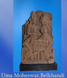
ବେଲଖଣ୍ଡୀ ଠାରୁ ପ୍ରାପ୍ତ ଉମମା ମହେଶ୍ଵର ମୂର୍ତି
ବେଲଖଣ୍ଡି
କେସିଙ୍ଗା ରେଳଷ୍ଟେସନଠାରୁ 32 କି.ମି. ଦୂରତାରେ ଅବସ୍ଥିତ ବେଲଖଣ୍ଡି ଶୈବପୀଠ ଦୁଇଟିନଦୀ ଯଥା ଉତେଇ ନଦୀ ଓ ତେଲ ନଦୀର ସଂଗମସ୍ଥଳୀ ଅଟେ । ଏହି ଦୁଇଟି ନଦୀ ମିଳିତ ଭାବରେ ଯାଇ ମହାନଦୀ ସହିତ ପୁନଶ୍ଚ ମିଶି ଯାଆନ୍ତି । ବେଲଖଣ୍ଡି ଶୈବପୀଠ ର ଆଧ୍ୟାତ୍ମିକ ପୃଷ୍ଠଭୂମି ତଥା ପ୍ରତ୍ନପତ୍ତ୍ଵିକ ବିଶେଷତ୍ଵ ରହିଛି । ୧୨ସହ ଶତାବ୍ଦୀ ସମୟର ଅନେକ ମୂର୍ତ୍ତି ଓ ପ୍ରସ୍ତର କାରୁକାର୍ଯ୍ୟ ଏହି ଅଂଚଳ ରୁ ଅବିଷ୍କୃତ ହୋଇଅଛି । ବିଶେଷ କରି ସପ୍ତମାତୃକା, ଉମା-ମହେଶ୍ଵର ଙ୍କର ମୂର୍ତ୍ତିସବୁ ଆବିଷ୍କାର କରାଯାଇ ମନ୍ଦିର ପ୍ରାଙ୍ଖଣରେ ଥିବା ଏକ ଛୋଟ ସଂଗ୍ରାହଳୟ ( ମ୍ୟୁଜିୟମ ) ରେ ରଖାଯାଇଅଛି । କଳାହାଣ୍ଡି ଜିଲ୍ଲାର ଏହା ଏକ ପର୍ଯ୍ୟଟନ ସ୍ଥଳୀ ଅଟେ ଏବଂ ସଦର ମହକୁମା ଭବାନୀପାଟଣା ଠାରୁ ୬୭ କି ମି ଦ୍ଵର ରେ ଅବସ୍ଥିତ ।
ଜୁନାଗଡ
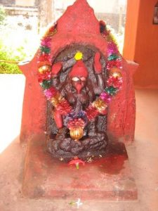
ଜୁନାଗଡ ସ୍ଥିତ ମା ଲଙ୍କେଶ୍ଵରୀ
କଳାହାଣ୍ଡି ଗଡ ର ବୁର୍ବ ରାଜଧାନୀ ହେଉଛି ଜୁନାଗଡ ଯାହା କି ନାଗ ବଂଶୀ ରାଜା ମାନଙ୍କ ଦ୍ଵାରା ଶାସିତ କରା ଯାଉଥିଲା । ଏଠାରେ ମା ଲଙ୍କେଶ୍ଵରୀ ଙ୍କ ପ୍ରସିଦ୍ଧ ପୀଠ ରହିଛି ଏବଂ ଅଞ୍ଚଳ ର ଆରାଧ୍ୟ ଦେବୀ ଭାବରେ ସେ ପୂଜା ପାନ୍ତି । କୁହାଯାଏ ସତୀ ପ୍ରଥା ର ବିଶେଷ ପ୍ରଚଳନ ଏ ଅଞ୍ଚଳ ରେ ଥିବା ପୁରାତନ କାଳକୃତି ରୁ ଅନୁମାନ କରା ଯାଏ । କିନ୍ତୁ ଇଂରେଜ ରାଜୁତି କାଳ ରେ ଏହା ସମ୍ପୂର୍ଣ ନିଷେଧ କରା ଯାଇଥିଲା
କର୍ଲାପାଟ
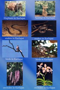
କର୍ଲାପାଟ ଅଭୟାରଣ୍ୟ ର ବନ୍ୟ ଜୀବନ
କର୍ଲାପାଟ ଭୟାରଣ୍ୟ ଭବାନୀପାଟଣା ଠାରୁ ମାତ୍ର ୧୦ -୧୨ କିମି ଠାରୁ ଆରମ୍ଭ ହୋଇଥାଏ । ଥୁଆମୂଳ ରାମପୁର ଅଞ୍ଚଳ ର ଏକ ଅଂସ ବିଶେଷ ହେଉଛି କର୍ଲାପାଟ ଭୟାରଣ୍ୟ । ଏହି ଠାରେ ଥିବା ଖଣ୍ଡଆଲ ଜଳ ପ୍ରପାତ , ତଥା ମା ମାଣିକେଶ୍ବରୀଙ୍କ ମନ୍ଦିର ଦର୍ଶକ ଙ୍କ ପାଇଁ ଏକ ମନୋରମ ପରିବେଶ ସୃଷ୍ଠୀ କରିଥାଏ । ପୂର୍ବେ ଏହି ଅଞ୍ଚଳ ରେ ନାଗ ବଂଶ ର ସାମନ୍ତ ରାଜା ମାନେ ଶାସନ କରି ଆସୁଥିଲେ । ଅଭୟାରଣ୍ୟ ମାନ୍ୟତା ପାଇବା ପରେ ଜଙ୍ଗଲ ଇ ଜୀବ ଜନ୍ତୁ ଙ୍କ ସୂରକ୍ଷା ପାଇବା ପାଇଁ ସରକାର ଙ୍କ ତରଫରୁ ବିଭିନ୍ନ ପଦକ୍ଷେପ ନିଆ ଯାଉଛି । ବର୍ତ୍ତମାନ ମଧ୍ୟ ଏହି ଭୟାରଣ୍ୟ ଅନେକ ଜୀବ ଜନ୍ତୁ ସୁରକ୍ଷିତ ଅବସ୍ଥା ରେ ବିଚରଣ କରୁଛନ୍ତି ।
ମୋହନଗିରି
ମୋହନଗିରି ସ୍ଥିତ ଷଷ୍ଠ ଶତାବ୍ଦୀ ର ଶିବ ମନ୍ଦିର
ମଦନପୁର ରାମପୁର ର ମୋହନଗିରି ଗ୍ରାମ କଳାହାଣ୍ଡି ଜିଲ୍ଲା -କନ୍ଧମାଳ ଜିଲ୍ଲା ସୀମାରେ ଅଛି । ଏହା ମଦନପୁର ରାମପୁର ସହର ଠାରୁ ୩୫ କି. ମି. ଦୂରରେ ଅଛି । ଗ୍ରାମଟି କାଳି ଗଙ୍ଗା ପାହାଡ ଶୃଙ୍ଖଳ ମଧ୍ୟ ରେ ରହିଛି । ଏକ ପ୍ରାଚୀନ ଭଗ୍ନ ଶିବ ମନ୍ଦିର ଏହି ଆଞ୍ଚଳ ର ବିଶେଷତ୍ଵ କୁ ପରିପୃଷ୍ଠ କରି ପାରିଛି ।
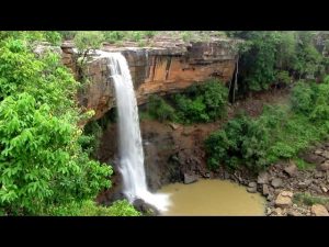
ରାବଣଧାର
ରାବଣଧାର ଜଳ ପ୍ରପାତ
ରାବଣଧାର ଜଳ ପ୍ରପାତ ଭବାନୀପାଟଣା ଠାରୁ ମାତ୍ର ୧୨ .୫ କିମି ଦୂରରେ ଅଛି। ଏହା ର ଚତୁର୍ପାସ୍ଵ ରେ ପ୍ରକୃତି ର ମନୋରମ ସୌନ୍ଦର୍ଯ୍ୟ ଦୃଶ୍ୟ ଦେଖିବାକୁ ମିଳେ । ଜଳ ପ୍ରପାତ ର ତଳେ ସରକାରଙ୍କ ତରଫରୁ ଏକ କ୍ଷୁଦ୍ର ଜଳ ପ୍ରକଳ୍ପ ଭଟ।ଙ୍ଗପଦର ଡ୍ୟାମ ନାମରେ କରାଯାଇଅଛି ଯାହାକି ଅନେକ ଚାଷୀଙ୍କ କୃଷି ପାଇଁ ଏକ ବରଦାନ ଭାବରେ ଫଳପ୍ରସ୍ତ ହୋଇଅଛି । ରାବଣଧାର ଜଳପ୍ରପାତ ଦୁଇଗୋଟି ଜଳପ୍ରପାତ କୁ ନେଇ ପ୍ରସିଦ୍ଧ । ଗୋଟିଏ ହେଲା ଛୋଟ ରାବଣଧାର ଓ ଅନ୍ୟଟିହେଲା ବଡ ରାବଣଧାର । ବର୍ଷ ତମାମ ଏହି ଅଞ୍ଚଳକୁ ଅନେକ ପର୍ଯ୍ୟଟକଙ୍କ ସମାଗମ ହୁଏ ଏବଂ ସବୁ ସମୟରେ ବଣଭୋଜି କରିବା ପାଇଁ ବହୁତ ଲୋକ ଏଠାକୁ ଆସି ପ୍ରକୃତିକ ପରିବେଶର ମଜା ଉଠାଇ ଥାଆନ୍ତି ।


